

- Arakan Army dismisses junta claims of defections in Ayeyarwady as fabricated propaganda
- Over 150 dengue cases, three deaths reported in Arakan State
- Poor leadership, disunity blamed for loss of northern Chin State to junta
- Free Arakan Lottery tickets distributed to IDPs across Arakan State
- Arakan Army, allies clash with junta convoy near Nat Yay Kan base
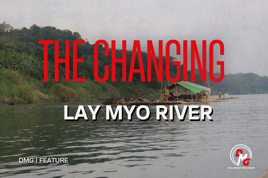
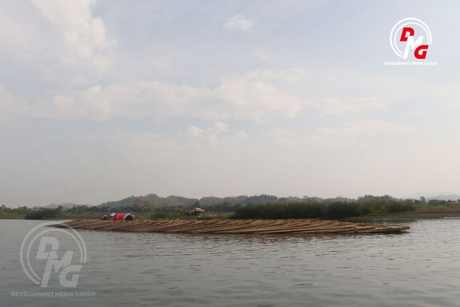
The Changing Lay Myo River
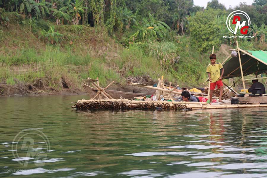
Under the scorching summer sun, 47-year-old Daw Oo Saw Nwe and three members of her family strain to push bamboo rafts that have become stranded after drifting down from the upper reaches of the Lay Myo River.
10 Jun 2026
DMG | Feature
Under the scorching summer sun, 47-year-old Daw Oo Saw Nwe and three members of her family strain to push bamboo rafts that have become stranded after drifting down from the upper reaches of the Lay Myo River.
At this same time last year, this section of the river was about six feet deep. This year, however, it is barely three feet deep and has turned into a shallow sandbank.
“A journey that used to take three days now takes about five days. Because the water is shallow, boats get stranded. When we cannot move forward, we have to stop at villages and wait for the tide to rise,” said Daw Oo Saw Nwe, who is over 50 years old and lives in Rwamani Village, Mrauk-U Township.
Her family has relied on cutting and selling bamboo from the Lay Myo River area for more than a decade.
Residents say that over the past 10 years, the river channel has become noticeably shallower year by year, while riverbank erosion in nearby villages has also worsened annually.
For local people like Daw Oo Saw Nwe and her family, who depend on the Lay Myo River for their livelihoods, the river is no longer a lifeline. It has become a “river of anxiety” that threatens both their livelihoods and their safety.
Why Is the Lay Myo River Becoming Shallower?
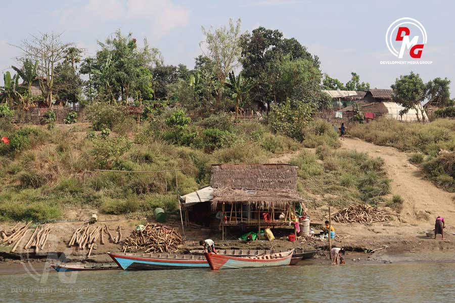
The Lay Myo River, the second-longest river in Arakan State, originates from Mount Victoria in Matupi Township, southern Chin State. It flows for more than 100 miles through Mrauk-U, Minbya and Pauktaw townships in Arakan State before emptying into the Bay of Bengal.
In the past, large boats could travel along the Lay Myo River as far as Paletwa in Chin State. Today, however, even during the rainy season, it is no longer easy to travel upstream beyond Shwe Tamar Village in Minbya Township.
The shallowing of the river has become so severe that areas once more than 12 feet deep and navigable by motorboats throughout the year now have only about three feet of water in some places during summer. Sandbanks have also become increasingly common.
“In the past, even a long bamboo pole about 12 cubits in length could not reach the bottom of this river. Now there are places where the water does not even cover your ankles. This is because the river has become shallow,” said U Inga Aung, a farmer from Chrit Chaung Village in Mrauk-U Township.
Silt carried annually by the Lay Myo River settles on the riverbed, gradually making the river shallower. In places where the water flow slows, sediment accumulates and eventually rises above the water surface as islands.
“When we were young, the Lay Myo River was not this wide, but it was quite deep. Now, during the summer, when the river level drops, we cannot even bathe in the river near our village because sandbanks have appeared. We have to go to the other side to bathe,” Daw Oo Saw Nwe said.
Severe storms and irregular rainfall have also accelerated riverbank erosion, causing soil to collapse into the river and contributing to the formation of sandbanks.
Water resources expert Maung Kyay Yay, also known as U Myint Thein, said deforestation in river basins and headwater areas has reduced the land’s ability to retain rainwater. As a result, rainwater carries excessive sand and fine silt directly into the river. When the current slows, these sediments settle, forming sandbanks and making the waterway shallower.
“Experts describe this phenomenon as deforestation and degradation of the catchment area. This process does not happen in a single year, but continues annually. Over many years, it damages the natural condition of the river and affects the livelihoods of people who depend on natural resources along the river,” Maung Kyay Yay said via email.
Local residents say the emergence of islands in the Lay Myo River has become more noticeable over the past decade.
The impact became especially visible after Cyclone Komen struck the Bay of Bengal in 2015, bringing record rainfall to northern Arakan State. River levels rose several feet above danger marks.
The cyclone inundated many villages in Mrauk-U and Minbya townships, destroyed roads and bridges, and caused severe landslides along the river. Residents say this event marked the beginning of major ecological changes in the Lay Myo River.
Although exact figures are difficult to provide, at least 10 large and medium-sized islands are now believed to have formed along the Lay Myo River, mainly in Mrauk-U and Minbya townships.
Some are temporary sandbanks that appear only during the summer, while others have become permanent islands where trees and bamboo now grow.
“When riverbanks collapse for various reasons, sand and silt are carried by the current and deposited wherever the river can no longer transport them. This creates sandbanks. Once a sandbank forms in the river, it becomes difficult to remove by human labor,” said water resources expert Maung Kyay Yay.
The Consequences of a Shallowing River
The shallowing of the Lay Myo River has become a nightmare for local people who depend on the river for their livelihoods. Daw Oo Saw Nwe, who earns a living selling bamboo, said shallow water causes strong currents, and bamboo rafts often crash into rocks or become stranded, leading to damage and financial losses.
“When timber rafts and bamboo rafts are sent down from the upper river, if we cannot control them even briefly, the rafts break apart. Then the bamboo cannot be recovered, and the logs float away. When that happens, everything is lost,” she said.
At present, many timber and bamboo traders from the Lay Myo River area have moved their businesses to the Dalet Chaung area of Ann Township.
The river’s decline has also badly affected local fishermen who depend on it for their livelihoods. As a result of the shallow water, fish have become increasingly scarce in the area.
Withering Orchards and the Lingering Wounds of Cyclone Mocha
The Lay Myo River basin is one of Arakan State’s key orchard-growing areas. But local residents say lime, sweet lime and pomelo trees are now dying for unknown reasons.
“I don’t know what has happened to the trees in recent years. They all dry up and die. Even big sweet lime trees wither and stop bearing fruit,” said Daw Oo Thein Hla, an orchard owner from Letpya Village on the banks of the Lay Myo River.
Daw Oo Thein Hla has grown hundreds of lime, sweet lime and pomelo trees, continuing her family’s traditional orchard work.
Because fruit trees in her orchard are dying before reaching long-term maturity, she has had to replant them. Now, only young trees remain in much of the orchard.
“I planted new trees before the old ones died, but now I cannot keep up. The trees die after only one or two years. Most of the trees now are only about my height,” she said.
In previous years, a single lime tree could produce more than 500 fruits. Now, growers say even strong lime trees fail to produce hundreds of fruits, and yields have sharply declined.
Farmers say many orchards along the Lay Myo River were damaged by Cyclone Mocha in 2023, while remaining long-term fruit trees have continued to dry out and die.
“After Mocha, rambutan trees dried up and died not long after. Sweet lime trees also became weak, their leaves thinned, and their branches dried. Soon after, they all died,” Daw Oo Thein Hla said.
Lime, sweet lime and pomelo are citrus species. According to FAO Plant Production and Protection Papers, citrus trees can become diseased and die after being exposed to flooding.
FAO disaster-related reports also state that tropical fruit trees such as rambutan, sapodilla and mango can suffer disrupted nutrient absorption after prolonged flooding, causing leaves to yellow and trees to die.
The Intergovernmental Panel on Climate Change (IPCC) assessment reports have also warned that climate change and extreme weather events can affect fruit production in local areas.
Local residents say orchards along the Lay Myo River are suffering not only from the lingering effects of Cyclone Mocha but also from rising temperatures and ecosystem damage caused by annual timber and firewood extraction.
Chit Chaung Village, on the banks of the Lay Myo River, has more than 80 households, most of whom depend on orchards and farming. Villagers say they now experience damage to orchards and paddy fields almost every year due to riverbank erosion and flooding during the rainy season.
“About two acres of my farmland and one acre of orchard have almost disappeared because of river erosion. During the rainy season, the current becomes stronger every year, and riverbanks collapse more frequently. Around one-third of my fields and orchards have already been washed away,” said U Inga Aung of Chit Chaung Village.
He added that flooding during the rainy season has also destroyed planted farmland.
Deforestation Under the Shadow of War
Local conflict is also a major factor behind environmental destruction. Since 2023, widespread power outages in Arakan State have forced residents to rely almost entirely on firewood and charcoal.
“In the past, even though we did not have electricity, firewood cutting was mainly for the Lay Myo area. Now, because of the war, firewood and timber are being cut for the whole of Arakan State. Deforestation has become very serious,” Daw Oo Saw Nwe said.
Large fruit trees and forests along the Lay Myo River are being cut not only for fuel but also to rebuild homes destroyed by the war.
“We bring timber down from the upper areas. Since timber is no longer easy to get as before, we see people selling even long-term mature trees because they are struggling with their livelihoods. Now, even trees that took decades to grow have almost disappeared,” Daw Oo Saw Nwe said.
According to Global Forest Watch’s 2024 report, Myanmar lost more than 700,000 acres of forest in 2023, and the Lay Myo region is among the most severely affected areas.
A Rougher River and Greater Danger for Residents
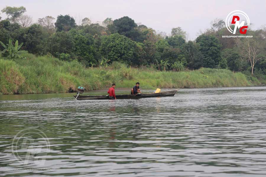
The increasingly rough river channel now threatens not only livelihoods but also lives. During the rainy season each year, strong currents have made river travel more dangerous for Lay Myo residents.
On August 16 during the 2025 rainy season, a motorboat capsized in the Lay Myo River, killing four local residents from Khwe Khaung Village in Paletwa Township, including two children.
“In the Lay Myo area, we trade fruits by motorboat and have to travel along this river. When the water rises, the current becomes extremely strong, and because the river bends sharply, it is very dangerous,” said U Inga Aung.
On August 3, 2024, two Muslim men from Pipinyin Muslim Village in Mrauk-U Township died while collecting firewood that had drifted down the swollen Lay Myo River. In Si Thet Muslim Village, another man died after his house collapsed due to river erosion.
On August 2, 2024, another man from Si Thet Village died while trying to rescue his son, who had been swept away by the current. Local people also say they lose buffaloes, cattle and other livestock every year due to rising river levels.
The river’s shallow but fast-flowing channel has become an unsafe route for travelers.
Restoration for Survival
Water resources expert Maung Kyay Yay said climate change is causing global warming, changing rainfall patterns, and increasing evaporation, which in turn alter river, stream and lake systems. Some waterways become shallow, some change course, and some dry up severely during the summer. These are all consequences of climate change, he said.
“Once environmental degradation begins in rivers, streams, lakes or any natural environment, if it is not prevented and controlled in time, the damage can continue for decades. Restoration will take even longer,” he said.
Because the natural condition of the Lay Myo River is changing rapidly, affecting local socioeconomic life and even threatening lives, restoration and conservation efforts are urgently needed.
Maung Kyay Yay said the idea that temporary sandbanks may naturally disappear after one seasonal cycle is only a hope.
“There may be many difficulties in using water resources. If those difficulties occur, solving them will require a great deal of time, labor and money. No one can say for sure whether they can be solved or not, because climate change is happening continuously,” he said.
Daw Oo Saw Nwe believes that strong-rooted trees should be planted near riverbanks to reduce erosion.
“It is not practical for only one village to build embankments to stop erosion. Planting strong-rooted trees could be a low-cost way to reduce riverbank collapse while also protecting against natural disasters,” she said.
At present, the Arakan Army (AA) controls and administers 14 townships in Arakan State. Environmental activists say the Arakan People’s Government, which is carrying out administrative functions in these areas, remains mainly focused on military and administrative matters and has not yet been able to give sufficient attention to environmental conservation.
According to an April 2026 statement by the Forest and Environmental Management Department of the Arakan People’s Government, residents in AA-controlled areas are permitted to cut only one ton of timber per year tax-free for household and basic livelihood use.
The department also warned that legal action would be taken if timber cut for household use is found to be sold commercially.
The Hopes of Local Residents
As Daw Oo Saw Nwe’s bamboo raft drifted down the Lay Myo River, crossing sandbank after sandbank, it remained in the river for many days. She still longs for the easier journeys of the past.
“In the past, we could travel calmly with the rise and fall of the tide. Now it is extremely exhausting. I want the old Lay Myo River back,” she said.
The Lay Myo River was once the heart of Arakan’s history. Named after the four ancient cities of Pyinsa, Purain, Narinjara and Taungoo Laungkyet, the river is now suffering heavily from human neglect and climate change.
For local residents, the hope is simple: to regain the clear, cool and safe Lay Myo River they once knew.

Opinion

Reflections on the Arakanese (Rakhine) Language Curriculum
By Admin 14 Jul 2026
Holding On to Arakan
By Admin 26 Jun 2026

The Arakan Shift and the Echoes of the People
By Admin 13 May 2026

We Must Remove What Is No Longer Needed
By Admin 24 Apr 2026
Grandmother’s Little Kerosene Lamp
By Admin 08 Apr 2026

Bangladesh’s New Foreign Policy Gamble and the Arakan Puzzle
By Admin 06 Apr 2026
POLITICS


BUSINESS
Industry to manufacture finished goods from coconut starting in early 2020
By Aung Kaung Zaw 20 Nov 2019